Great Divide (NOBO) - Day #8 San Luis, NM to Abiquiu, NM
Great Divide (NOBO) - Day #8
June 3, 2022
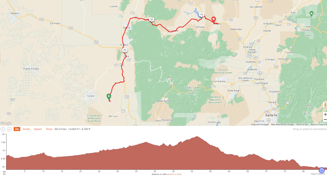
San Luis, NM to Abiquiu, NM - 86 Miles
Start 7:05 AM Finish 6:16 PM
Total Duration 11:11
Moving Time 7:00
Stopped Time 4:11
Ascent 4,084 Feet
Descent 4,786 Feet
Tour Total 577 Miles
Details at: https://ridewithgps.com/trips/92150561
I slept great last night at Informal Campground 24, about eight miles east of San Luis. I cracked the whip last night and forced myself to finish yesterday‘s report before going to bed. I slept in my silk sleeping bag liner and laid my sleeping bag over myself, like a blanket. I was comfortable and it was absolutely quiet. I had found only one old squashed can at the site by the tree.
This morning I started back to the road wearing my jacket and leg warmers. It was difficult going uphill through the deep sand, and my foot-downs were in the same places as yesterday. It was great being off-road again. Most of today would be on pavement and I was relishing the bumps, jumps, and maneuvers. As I was packing up my tent this morning, I was thinking about New Mexico and how it was called the ‘Land of Enchantment’. For me, the driving force has been the wind. It’s been generous to me out on the road and it’s been a constant throughout my time here. In camp or at stops the wind has been mischievous. Several times items have blown away. I needed respect it’s wily ways. It’s rustled through my clothing and has whispered in my ear. Whenever I cross it, it roars. It flaps my tent throughout the night.
I stopped to remove my jacket and leg-warmers and lather sunscreen and add my arm protectors. I prefer to stop when I have something to lean my bike against, but there weren’t those sorts of luxuries out here. I came to a T and took a right on dirt towards US 550. I had a great section downhill and then went around a bend and could see the highway a mile in the distance. As I got closer to the highway I noticed a sign that I was leaving public lands. I observed a lot of traffic when I got there, so I turned on my rear flashing light and installed my side-view mirror. I couldn’t get the radar to work. I entered four-lane highway US 550 and immediately crossed Rio Puerco.
I had a nice shoulder alongside the highway. There were rumble strips and a white line to my left. Gravel off-road was so much better than being on the highway. For the next two days I was just going to have to power through it. I passed a sign that read, ‘Elevation 6,700 feet’. The next few days would be the highest elevations of the tour. I was keeping my fingers crossed for good weather conditions.
After a few miles I began to notice buildings. There was a large mountain range to the north east. I passed a sign that read, ‘Elevation 6,800 feet’. Today was obviously a climbing day. Originally it had been a rigorous climbing day, but the park was closed. The highway grades would be easier. I rode into Cuba, population 735 and elevation 6,905’.
The Cuban café was packed and the service was poor. That said, I managed to get a double breakfast of huevos rancheros plus a pancake and sausage with extra eggs, along with two orange juices and ice water. I had brought in my two squished plastic water bottles to be refilled and I inflated the first with my mouth. A horrible screech filled the restaurant and everyone fell silent. Then I had to inflate the second. I sat at a table with an outlet and charged my devices while I uploaded reports and posted my socials. I took care of a little hygiene in the bathroom and got my water bottles refilled. It was all good. I noticed many Native Americans, and a lot of people with disabilities. Numerous people were wearing masks.
After breakfast I continued on US 550 north. There were four lanes of traffic and I crossed back over the Rio Puerco. Water was flowing below. I passed a sign that read, ‘Elevation 7,000 feet’. I crossed Arroyos San Jose, which was empty, and then came to State Highway 96 and took a right. Highway 96 had two lanes of motor traffic and barely a shoulder. Fortunately there was very little traffic.
A week ago at this time I was arriving in El Paso and being picked up by Jeffery Sharp. What a blur it had been! I wondered the whereabouts of the other northbound riders whom I’d met. I wondered if I’d catch up to any riders ahead of me. Two white dogs ran out from their house onto the highway and barked at me. I had my spray in hand but didn’t use it. They weren’t mean.
I was bypassing the San Pedro Parks Wilderness and enjoying an incredible tail wind. I saw a provocative looking military aircraft that resembled a Harrier. It had large propellers and seemed capable of taking off and landing both vertically and horizontally. I stopped at the Regina Mercantile for a Coke. Afterwards I crossed the Rio Arriba County line.
I came to the junction of Highway 112 and took a right going east while staying north of the forest fire closures. This area was noticeably greener. There was lush green grass and the trees were fuller. I noticed water in the streams.
The next town I passed was Galina, no population listed and no services. The Kountry Kwick store seemed to have been closed for a long time. I passed the Coronado high school and the post office. I saw a sign that Abiquiu was thirty-four miles ahead.
I called ahead to the Abiquiu Inn to see if they had any rooms available. My service was horrible and I had to call several times. It finally became clear that to make a reservation I had to reserve two nights. It seemed like I would be camping tonight. This was why I charged my devices every chance I got. No matter where I slept, I’d have beer tonight in Abiquiu.
I had a double dog chase. The bigger of the two was more threatening, yet the smaller one lasted longer. In the end, neither one needed to be sprayed. I was continuing to climb and was now at 7,830’ elevation. There were pine trees to both sides of the road and I enjoyed the fragrance. I was now at a much higher altitude, and it was a contrast from where I had spent last night.
I relished an incredible 500’ downhill over several miles. It was exhilarating! Along the way I passed the Coyote Ranger Station. It was 1:55 PM and I was twenty-five miles from Abiquiu. I came to another downhill sign and let it rip. My top speed was thirty-eight miles an hour, which I believe was the fastest I’ve ever gone on my Salsa. I noticed a sign about preparing to stop for one lane road construction.
I was enjoying the incredible dark sienna rock formations and came to the construction area. They were rebuilding a bridge and I noticed water in the stream below. There were ginormous white puffy clouds to the east. Somewhere in the plains to the east would be the recipient of all that rain. I rode through the town of Coyote, no population listed and no services.
The next town was Youngsville, no population listed and no services. I was back down at 6,500’ elevation. My surroundings were scrubby and similar to yesterday’s terrain. I reached out to Goldie in Abiquiu, who had a retreat along the Chama River which was listed on the ACA map. I could have a hut for the night or tent camp. I rode by Abiquiu lake and the water level was extremely low. There was a campground up at the lake which was another option. I could see an extremely tall range to the east with snow on some of the peaks.
I came to the intersection with US Highway 84 and took a right towards Abiquiu. I was five miles from my destination and it was 3:30 PM. I flew down the large hill and crossed over the Chama River and entered into Abiquiu. In the Tewa language Abiquiú means "wild choke cherry place". It was the home of American painter Georgia O'Keeffe, and her home and studio were in town. Many of her paintings depict scenes near Abiquiu.
I stopped at Bodes for a coke on ice, and then rode though town. I enjoyed the adobe architecture. I stopped at Cafe Abiquiu and ordered a Santa Fe Brewing Co Squeezer Radler. My server had ridden cross-country and was hip to my vibe. I ordered several more beers, in addition to chips and guacamole. He encouraged me to order the lamb burger and fries, which I enjoyed. He kept circling around to talk more bike touring stuff, and later got in trouble for bringing me too many beers.
After dinner I returned to Bodes General Store for a six pack of Samual Adams and a bottle of Jose Cuervo ready to drink margaritas. I cycled back up US 84 to the red mailbox, and then found my way to Goldie’s bike hostel. I showered, and then met Andrew and Kim who had started the Divide on May 24th. We shared cycling stories, and I learned that Patrick and Rachel from day number one had bailed. I heard from Otto and Nora who were currently in Cuba.
After Andrew and Kim retired to their teepee, I sat outside at a table amongst swarms of bugs while drinking beer and editing this report. I relished my last night in New Mexico.


Comments
Post a Comment