Great Divide (NOBO) - Day #7 Grants, NM to San Luis, NM
Great Divide (NOBO) - Day #7
June 2, 2022
Grants, NM to San Luis, NM - 98 Miles
Start 7:36 AM Finish 6:56 PM
Total Duration 11:20
Moving Time 9:27
Stopped Time 1:53
Ascent 4,665 Feet
Descent 4,432 Feet
Tour Total 491 Miles
Details at: https://ridewithgps.com/trips/92150667
I slept great in room 101 of the Southwest Motel in Grants. I stayed up later than I should have, but the reports were caught up! Woohoo! I was sound asleep in my comfy bed with a distant murmur of the highway and freight trains. There was a knock on my door which startled me. Had I overslept? I shouted, “What time is it?”. It was 7AM. Time to get going. My left heal was chapped and I needed ointment. I put on my socks to protect it.
I was now on map number five which would take me to Salida, Colorado. I went through Salida last summer on the Western Express, and I was having food, vitamins, and chamois butter mailed to a hostel there.
I left the motel and stopped at an Alon store for some petroleum jelly, a Starbucks Mocha Frappuccino, a Dole 100% Orange Juice, a Mrs. Freshley’s Jumbo Honey Bun, and two liters of water. I wanted insurance in case I couldn’t find any out there today. I removed my jacket and leg-warmers at the store. I lathered myself with sunscreen, applied petroleum jelly to the bottoms of my feet, and put on my arm protectors.
I would be following ACA‘s recommendations and bypassing Cibola National Forest, which was closed because of fire danger. I cycled west out of Grants on highway 122. The wind was once again out of the southwest. I passed dozens of old shuttered businesses and attractions along old Route 66. On the far end of town I noticed a sign, ‘Do not pick up hitchhikers. Prison Facility’.
I took a right on Highway 605 heading north towards Cuba. The first leg of this detour made use of the ACA Chaco Alternative, which was all asphalt. I was spoiled by the pavement, zero grade, and tailwind. The highway was four lanes wide with no shoulder I heard a truck honk far behind me and realized my rear tail light wasn’t on. In addition, my radar was off and I didn’t have my side-view mirror attached. There was hardly any traffic on the road, and the honk was unnecessary. After a few miles the highway merged down to two lanes. I was surrounded by dried-out grass, sage brush, and scrub. There were distant buttes and mesas to the left, and mountains of the Cibola National Forest to the right.
I rode around a bend and crossed the McKinley County line. After eighteen miles I came to the turn off for highway 509 where the Chaco Alternative continued. I would remain on highway 605 towards San Mateo. I crossed the Cibola county line, and noticed Mount Taylor in the distance. There were radio towers on top of it.
I took a left outside of San Mateo and then another left headed towards 456 and the route. I was still on asphalt. It was 10 AM and I had pedaled twenty-seven miles. Right before I rejoined the route I began seeing signs that the Cibola National Forest was closed because of fire danger. ACA knew what was going on. Back on route I had a fantastic downhill on asphalt. I stopped to flip my map outside of a blasting area and realized that I had missed a turn. Going forward the route would be gravel.
I went flying down the gravel and really enjoyed the ride. It was a steady downhill and I had a strong tail wind. After a few miles I got to an intersection and decided to check my digital map. I had gone way off route. I had to face the wind and climb back up to where I’d been earlier. I was supposed to have been on a dirt road with a slightly different heading. I finally got it all straightened out. It wasn't like there were any road signs out here.
I enjoyed 8,025’ Cerro Alesna to my right. It looked like an ancient volcano core. I was In the middle of nowhere and surrounded by dirt, grass, a little bit of scrub, and some rocks. It was incredible!
I came to the tour’s first gate that I was supposed to go through. Hopefully I wouldn’t have to drag my bike underneath any gates or lift it over the top. A small red pick-up truck passed me going in the other direction. Bicycle tracks were somewhat visible in the dirt. I passed an abandoned homestead built out of stacked rocks. There was a corral behind it. In the middle of nowhere I encountered some sections of discarded corrugated steel drain pipe. I then crossed over a small stream with stale still water. Grass was thriving down in the moist ditch.
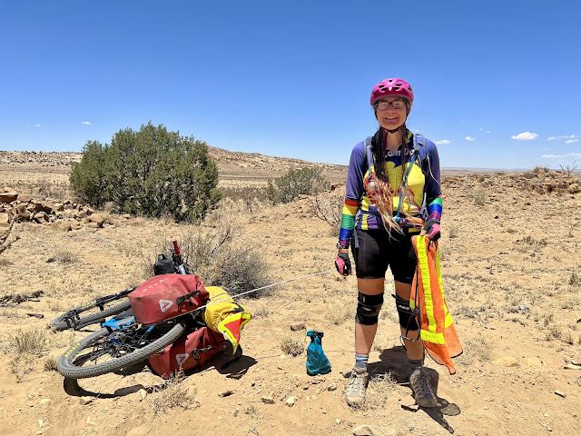
I entered the Sandoval Ranch which had been established in 1976. I noticed a bright red object ahead on the side of the road. It was a bicycle. I met southbound cyclist Carla from California whom had been enjoying lunch underneath a tree. She was touring the New Mexico section of the Great Divide, and told me about water sources and camping possibilities to the north. She mentioned that there were three northbound cyclists two days ahead of me.
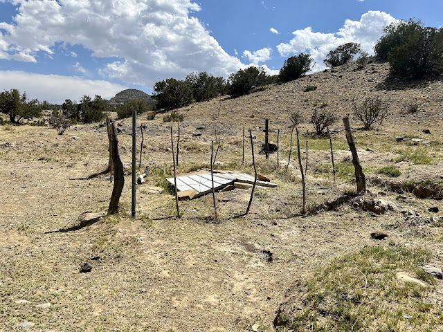
I enjoyed riding through badlands all day long, surrounded by dirt, rocks and scrub. I never saw the windmill that Carla had mentioned, but I did find Ojo Frio. There was a large pool for cattle, and the actual water source was surrounded by a barbed wire fence. Corrugated metal, weighed down with heavy rocks, was laid over top the spring. I filtered two liters of cold water and drank half of it.
I passed the first designated campground, which was essentially dirt, sand, and a few scraggly trees. I had ridden seventy-five miles and it was 4 PM. I decided to push onto the next site. Looking ahead, I was now planning to grab a meal in Cuba tomorrow, and then push all the way to Abiquiu, where I’d spend the night. Because of the park fires, I would be on pavement for the next two days, and figured that I could make it to Colorado by Saturday night.
Cloud cover emerged, and I enjoyed the shade. There were massive clouds to the east. I crossed the Arroyo Chico on a bridge. Most of the dried stream crossings involved riding down into a ditch, and then climbing back out the other side. I was on dirt Road 279 and climbed up out of a valley onto a ridge. Cerro Cuate was to my right.
I was riding some washboards and I hit a big bump. I had a suspicious feeling and glanced over my shoulder. My two purchased bottles of water were laying in the middle of the road. This was why it was necessary to always fill water bottles at every opportunity.
I came to a T and took a right on dirt road 79 aka San Luis Road. I was in my own world, listening to a WFMU $mall ¢hange file, and was startled when I heard a honk behind me. The driver of a white pick-up truck waved as he passed. The clouds to the south had gotten dark and I saw on Dark Sky that there were storms to the south.
I came to the turn off for San Luis. The town was off route, had a population of 59 people, and had no services. I took a left on Torreon road which was paved. There was also a considerable amount of motor traffic.
I climbed a giant hill and then took a right on dirt BLM road 1102. I pedaled for a few miles and came to a turn-off for the informal campground. Essentially I was in a cow pasture. The track hadn’t seen much traffic and there was thick sand. I eventually spotted a nice looking tree and decided to stop. I swept the area clear of cow patties and sticks, and then set up my tent. It was still warm and I opened up both fly flaps to allow a breeze through my tent.
I ate slices of parmesan cheddar cheese with taco shells, as I edited this report.
 |
| Cibola National Forest Fire |
 |
| Endless badlands |
 |
| Abandoned homestead |
 |
| Corrugated drain pipe out in the middle of nowhere |
 |
| Dirt, scrub, and boulders |
 |
| Ojo Frio water source |
 |
| Ojo Frio cattle pool |


Comments
Post a Comment