Great Divide (NOBO) - Day #23 Falls Campground, WY to Jackson, WY
Great Divide (NOBO) - Day #23
June 19, 2022
Falls Campground, WY to Jackson, WY - 81 Miles
Start 6:35 AM Finish 4:52 PM
Total Duration 10:17
Moving Time 7:06
Stopped Time 3:12
Ascent 3,064 Feet
Descent 5,215 Feet
Tour Total 1,685 Miles
Details at: https://ridewithgps.com/trips/93959276
I slept well in USFS Falls Campground. Last night as I was setting up my tent the mosquitoes were vicious. There was a thick steel bear box in my campsite, which even I had trouble opening. It put my mind at ease to store my food within. In addition to all the other stresses and difficulties of long distance bike-packing and living outside, I now had to worry about grizzly bears. I kept a can of bear spray right next to my head when I slept. Last night I did a little work on yesterday’s report and edited yesterday’s photos, but after a full day’s riding I fell asleep as soon as I was horizontal. I got up in the middle of the night for water. I woke up with the birds that began chirping before the dawn. It rained throughout the night and I had to roll up a wet tent. There was a dumpster in the campground where I finally got rid of the leftover cans from when I camped near Cow Camp Springs.
I took a right on US 287 and backtracked to the gravel fork. The stunning rock outcrops from Pinnacle Butte were directly above me. It was cloudy and overcast. I was cold, particularly my fingertips, but I figured the climb would change that. I took a left on gravel Park Road 515 aka Brooks Lake Road, and turned off my rear light. It would be a twelve and a half mile ride up to Togwatee pass. I was still upset about losing my iPad, and was thinking about how rough this was. I was constantly having to remember to fill my water, keep my devices charged, and keep my gear organized and in working order. Then I thought about that racer last night who had to climb the thirty-eight miles up Union Pass to get to the warm shelter. She had most likely finished in the dark.
I eventually did warm up on the climb, and didn’t need the long finger gloves. I’m unable to use my iPhone with my long finger gloves, despite the fact that they were advertised to work with screens. I was riding beneath Seneca Butte which I remembered from my 2018 TransAm tour. The rock formations were stunning, and off-road I would be getting even closer. I saw a porcupine and then I saw a pronghorn. There were melting piles of snow and the streams were flowing down the road. My friend Chris had warned me that I had snow ahead in Montana. I was also aware that there were muddy areas ahead. A southbound racer passed and Brooks Lake was to my right. I noticed more stunning rock outcrops as the clouds cleared. I passed a fantastic campground on the lake, and then I came to a cluster of handsome buildings including Brooks Lake Lodge.
I came to a Y in the road. The cleared nice road went down to the lake. The other road was narrow, muddy, and was blocked with a big pile of snow. There was a warning sign to not travel this road when wet. Guess which road my route took? I stopped first to put on my waterproof socks. Curious horses in a nearby corral watched me. There were so many bicycle tracks on the climb, and I came to more snow crossings. I rounded a turn and could see Highway 287 down in the valley below. The last stretch up to the pass was badly rutted and speckled with large recently fallen boulders.
The mud was bad. It had clay in it, which caused it to stick and cling to everything. It was tenacious and had the viscosity of peanut butter. Because of my foot-downs and hike-a-bikes, my sandals and pedals were caked with mud. I had lost my SPD clipping capability, and my feet were sliding around on the pedals. Negotiating a path forward, sometimes the mud would be easier and other times the snow. If the snow was hard packed, I could ride over it. Other times I sank through. Often I would have to hike-a-bike. Because I’m right handed, I always walk to the left of my bike. The foot tracks from the southbound racers were on the other side.
The mud and the snow was intense. I was only wearing waterproof socks with no additional wool or silk socks. My feet were frozen, and I wondered if this is what I had in store up north. It was really tough and I almost wiped out, but quickly saved myself. Then on the downhill I came to an area that was deeply rutted. Essentially the road was destroyed and unridable because idiots in ATV motor vehicles had disobeyed the warning signs. I had no choice but to hike-a-bike.
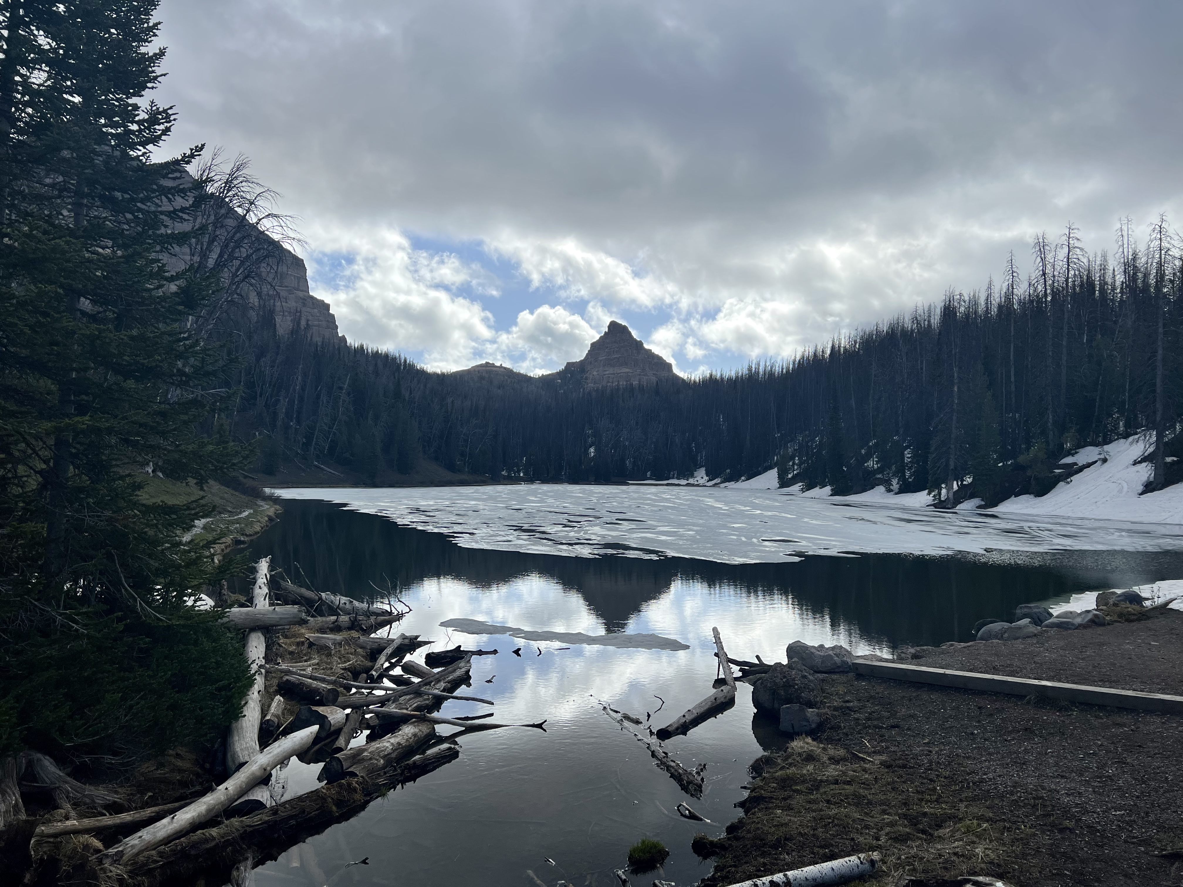
I finally came to the intersection of US Highway 287, and passed a small lake that was still frozen. I documented 9,658’ Togwatee pass and spent a moment cleaning my bike and wiping off the thick mud and snow. Wow! That was harsh! I could have just taken the highway. Talk about choosing the hardest way to do something! And then I crossed the Continental Divide, and was once again on the Pacific side. I stopped for a documentation photo and was pleasantly surprised to see a sticker from my 2018 tour. It had weathered the past four years quite well.
I met racer Dave from Steamboat Springs, who was trying to make it to Pinedale today. I warned him about the mud and the snow, and suggested that he could stay on the highway. Like me, he was a glutton for punishment and couldn’t do that. I enjoyed the downhill on pavement, and surprisingly didn’t get too cold. I approached an even steeper downhill with a 6% grade, but the route took me back off the highway.
I stopped at Togwatee Mountain Lodge, where I met Brent from Salt Lake City. The cafe was closed, so from the lodge I purchased a Hostess Jumbo Honey Bun, Starbucks Frappuccino, Dole orange juice, and two Honey Pocket ham and cheese sandwiches. Brent and I sat together out on the front porch. He told me he was riding between 130 and 140 miles per day. He was hoping to make it to Pinedale today.
I was now on Forest Road 30050. The air got chilly so I pulled over to put on my down sweater. There had been a storm here a few days ago, and I scrambled over three downed trees on this section. Dark clouds appeared, and it started to rain. My tires were kicking up mud, which was flying everywhere. My calves were being ricochetted with chunks of dirt, and then I heard a thunder clap. It started to hail. Fortunately there was some tree cover, and I continued. The rain began, and I eventually came to the other end of the closed gates. I was at a T and took a right on a much better quality dirt road, that was wider and had been serviced. The wind and the rain were cold. I met racer Peter as he was climbing.
I came to Turpin Meadow Ranch, which was another handsome collection of buildings. I sought refuge from the rain underneath a portico, where I added sock layers. I then set back out in the rain, and crossed the roaring Buffalo Fork Creek. It was full on rain, but I now had pavement. I rode by Tracy lake and then rounded a bend and could see the stunning Teton range ahead. I rejoined US 287 and my eyes were glued to the mighty Tetons to the west. I ran into south-bounder Chris from Seattle, who had started at the border on June 10th. He had barely beaten the storm up north, and described the brutal conditions. I entered Grand Teton National Park. I remembered from 2018 that bikes were charged the same fee as cars and RVs to enter the park, so this time I rode far to the right boat inspection lane and wasn’t stopped.
I came to a T at Moran and remained on US 287 aka US 191 aka Wyoming 89 towards Moran Junction. I finally got Internet service and called the Wind River brewery in Pinedale. I spoke with Hannah and they hadn’t found my iPad. I was disappointed. A few minutes later a voicemail appeared on my phone. The hostess at the brewery had located it! Woohoo! I eventually reached the Jackson Spur route and took a left headed south towards Jackson. In 2018 I had ridden south as far as Jenny Lake. I was currently thirty-three miles from Jackson and, despite the cloud cover, the Teton range was incredible.
I crossed the Jackson Lake Dam and the origin of the Snake River. I was surprised at the low water level in the reservoir. The sun was trying to come out, and I rung the water out of my long finger gloves and put on my shorts finger gloves. I ran into north-bounders Caity from Boulder and Jens from Munich. Caity had started at the New Mexico border on the 21st of May and was going to Jasper. She was blogging at https://www.caitymilton.com/blog. Jens was riding the Western Wildlands route to the Grand Canyon, before taking a connector trail over to the Great Divide Mountain Biking Route. I promised them that I would catch them in a few days.
I stopped alongside the road to remove my wet layers, all the way down to my short sleeve shirt and bare feet. All of my clothes were covered with mud, as was my bike. I also spent a moment cleaning my chain which had been sounding crunchy. Some things aren’t as good the second time around but the Tetons did not disappoint. As I wrote in 2018, I felt like I was in the movie Narnia, or perhaps Game of Thrones. There’s something foreboding about the Tetons. They jut up out of nowhere. And they’re massive
I turned into Jenny Lake to get on the bike path, where I met a couple who were going to coast to coast from Seattle to Maine. They were off route because of the Yellowstone closures and needed a place to camp. I told them about the hiker biker site here, and said that it was my favorite camping spot ever. In 2018 I had seen bear cubs in the evening and bears fishing out of the lake the following morning.
I got cold again, so I stopped to re-don my jacket. I decided to leave the alternate route and stay on the bike path that went straight from Moose to Jackson. The rain picked up and I stopped in an underpass to put on my rain pants, wool socks, and waterproof socks. As I was nearing Jackson I booked a hotel and strategized how to most quickly get to Pinedale and back. There was a car rental place near my hotel which would be closing soon. I figured this would be the fastest and least expensive way to do it.
I entered Jackson, population 9,577 and elevation 6,209', and could see the ski trails on the large mountain ahead. The guy at Thrift quoted me $85 for a car rental. I dropped off my bike at the hotel and then jumped in the car for the ninety minute drive back to Pinedale. The drive was gorgeous, and it rained several times. I talked to my son along the way, who wished me a happy Father’s Day. At Wind River Brewery I ran into my server from Friday who remembered me. I recovered my iPad, and headed back to Jackson. All told, including taxes and gas, getting my iPad back back cost me $125 and three hours. Hopefully I had learned a lesson. I would now be checking for it every time I packed or unpacked my panniers.
Before I returned the car I stopped at an Albertsons for more pork and beans, refried beans, and a can of apricots. I also got myself a six pack of Fat Tire and a bottle of margarita mix. Back at the hotel I took a hot shower and enjoyed a few margaritas. I went next door to Melvin Brewery where I enjoyed several glasses of Carl Fredrickson IPA along with a Wyoming Rodeo Burger. I retired back to my hotel room where I crashed hard.
 |
| USFS Falls Campground |

 |
| Tour Divide Racer |

 |
| Brooks Lake Lodge |

 |
| Tour Divide tire tracks |


 |
| Tour Divide racer Dave from Steamboat Springs, CO |


 |
| Tour Divide racer |
 |
| Tour Divide racer Brent from Salt Lake City |
 |
| South-bounder Chris from Seattle |
 |
| Me in front of the Grand Tetons |

 |
| Me in front of the Grand Tetons |
 |
| North-bound divider Caity from Boulder, CO |
 |
| North-bound divider Jens from Munich |
 |
| A lot of wet muddy clothing |

 |
| A well deserved pint of Melvin Brewery Carl Fredrickson IPA |
 |
| Map/Elevation Profile |


Comments
Post a Comment