Great Divide (NOBO) - Day #4 Willow Creek Campground, NM to Valle Tio Vinces Campground, NM
Great Divide (NOBO) - Day #4
May 30, 2022
Willow Creek Campground, NM, to Valle Tio Vinces Campground - 62 Miles
Start 8:23 AM Finish 5:50 PM
Total Duration 9:27
Moving Time 7:17
Stopped Time 2:11
Ascent 3916 Feet
Descent 3705 Feet
Tour Total 289 Miles
Details at: https://ridewithgps.com/trips/91758305
Last night was this tour's best night’s sleep yet. I was blessed with perfect timing to find a gorgeous campground in the nick of time. The stars were just starting to sparkle as I set up my tent and hung a bear bag. It was dusty in the campground, and the black dust found its way into everything. I slept in this morning. My tent flap zipper got stuck as I was desperately trying to exit to water a bush. I wasn’t unable to unstick it, and eventually had to cut it out and stitch up the hole. I was out of water and had to filter from nearby Willow Creek. Everything was covered with dust.
It was cold this morning in the campground. I momentarily lost my parachute cord, but meanwhile found my EarBuds with the mini adapter. I could use my iPod after all. Trying to keep track of everything is a challenge. These tours take a beating on my body and my mind. The road out of the campground was more civilized than what I had been on yesterday. For example, there were road signs. It was warmer out on the road once I got my heart beating under the sun. I looked at the maps before going to bed last night and didn’t know if Pie Town would be possible today. It was about 80 miles away, which would be possible on asphalt, but I wasn’t sure what kind of roads I’d be on. I climbed back out the valley. The hills to both sides of the road were littered with tree trunks from the 2012 forest fire.
It was a long climb to the top of the ridge and I got warm. At the top there was a gate capable of shutting down this section of road. I saw a guard rail for the first time since Mogollon and a sign for 28 which was listed on my paper route. I was getting closer to civilization and being back on route. A US Park Service Ranger drove by in a white pick-up truck and I quickly lifted up my buff to filter the dust from my nose and mouth. The wind today was still out of the southwest. I was wearing my jacket and leg-warmers. I got to a nice section where I was riding through pine trees. I then had a pleasant downhill, which was a long and gradual payoff from yesterday’s climb. From one of the peaks I could see a ginormous flat grassy plain to the east.
I was riding through open range and passed a group of cows enjoying the shade under a pine tree. I cycled washboards and thick gravel. I knew I was getting close to civilization when I passed a rustic phone booth. It had to be the last one in existence. I came to a stop sign and a T. There were signs for Beaverhead to the south and warnings about the fire. I took a right on 28 aka Bursum Road. I was still on gravel and began to climb. It was getting hot so I pulled over to remove my rain jacket and leg-warmers. I lathered myself with sunscreen and put on my arm protectors. There wasn’t a cloud in the sky. It was absolutely gorgeous and I couldn’t believe how different this terrain was from yesterday or even two days ago.
It was great riding through the pine trees. Many were marked with bands of orange spray paint. Several vehicles passed me including a pick up-truck pulling a trailer with a large water tank. I crossed a cattle guard and then came to a downhill sign. I was on Elk Mountain.
I had a fantastic downhill on a narrow gravel road through the trees. It reminded me of skiing this past winter in Vermont. Cycling in the summertime, though, is so much better. I finally came to the intersection with Oak Canyon Road and I was back on the route. I found myself in a grass savanna dotted with scrubby trees. I noticed that some of this area had been intentionally burned, perhaps for training. I passed encampments of large tents and mobile homes, ostensibly for firefighters.
The wind out of the southwest was intense and fortunately I was taking a right to the northeast. I would soon have a fantastic tailwind. I entered and rode through a beautiful canyon. There were two hundred foot rock walls to either side of me. Within the canyon grew long yellow grass and scrubby pine trees. By 12:30 PM I was at informal campground 4, where I had originally planned to spend the night. I was still 56 miles from Pie Town with about 2,000 feet of climbing ahead. I passed the Y Canyon Ranch and an interesting rock outcropping at Hoodoos. And then I came to a ginormous open valley. Grassland stretched forever with ranges far in the distance. It was incredible!
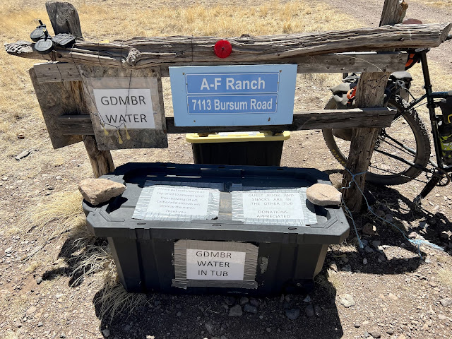
My lower water bottle cage was shot from the bumps and I needed to get a new one. I also needed to undo the lock on my phone. It was driving me crazy. Someone needs to engineer iPhone settings for cyclists. I cut around to the west side of the valley along the ridge. I was now on Rural Road B019. I was worried about water and was conserving my intake. I noticed a ranch alongside the road, and low and behold I saw a large cooler with a sign advertising water and snacks. Thank you Trail Angels AF Ranch! I filled my water bottles and guzzled from the gallon jug. I enjoyed two packages of Nabisco Lorena Dunn shortbread cookies and two packages of Kar’s sweet and salty mix. I signed the guestbook and left a donation. I had ridden 45 miles from the campground and, once again - in terms of water, it was perfect timing.
My left arm protector has been sliding down my arm on the bumps for days and it’s been driving me crazy. I think my right one stays up because it’s my dominant hand and the bicep is larger. I now understand why Chris had safety pins on his list. I stopped in front of the Salvos Ranch to flip my map. I saw mule deer running across the road. In the distance I could see State Highway 12.
I finally reached the highway there was a ranch at the T. I decided to take a break under the shade of a bush and drink some water. Afterwards I enjoyed my hundred feet of pavement. I then took a left on Mangus Road towards Valle Tio Vinces. I was now on Catrone County Road A095. Eventually I crossed a cattle guard and entered National Forest land. I climbed up into the forest and appreciated the shade that the pine trees provided. I followed a dried-up stream to the east.
I came to the campground and did my Goldilocks routine to find the camp site that was just right. All of them had picnic tables. What I wanted was a flat space to set up my tent. The less dust and dirt the better. I finally made my choice and began setting up. Thirty minutes later a white van pulled in and did the same routine. I noticed that they found a level spot on grass, and then they used a pair of small leveling ramps to park their van. I sat at the picnic table and edited yesterday’s report, while relishing a bag of Apllenty Refried Beans. I devoured a Beef Summer Sausage along with a few taco shells. Soon it got cold and I put on my down sweater, jacket, and leg warmers.
The campers’ dog came over to greet me and I was soon joined by Erin, from Durango CO. He was also a cyclist, and his brother-in-law owned the Little Toad brewery in Silver City. He mentioned that he had seen three loaded gravel bikes there yesterday. Erin brought over a few beers, which I relished. His wife came over and they told me about their outfitted van. Soon it was dark and cold, and time to go to bed.
 |
| Beautiful campsite in Gila National Forest |


Comments
Post a Comment